Home/
Registry/
Ford/
Mustang/
1964-1973/
“Project Car”/
Photo
supermotors.net/registry/media/982282
45th Tecate SCORE Baja 500 (2013) Official Course Map & Race Route

Reference · 1964-1973 MustangAll 42 brochures & literature

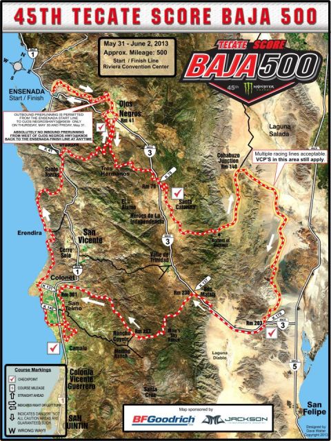










Promotional Baja 500 off-road race course map poster showing the route, checkpoints, and sponsors.
Part of 1964-1973 Ford Mustang Brochures & Literature
This document is the official course map for the 45th Tecate SCORE Baja 500 off-road race, held May 31, June 2, 2013, with an approximate race mileage of 500 miles. The start/finish line is at the Riviera Convention Center in Ensenada, Baja California, Mexico. The map, overlaid on satellite imagery, traces the race route from Ensenada east through Ojos Negros (race mile 41), to Cohabuzo Junction (race mile 140) near Laguna Salada, then south past Santa Catarina, San Matais (Rm 230), Rm 203 near Highway 3/K79, then west through Mike's Sky Ranch, Rm 262 near Rancho Coyote, Rm 301 near San Telmo and Colonet, and back north through San Vicente, Santo Tomas, and Ensenada. Checkpoints are marked with red check symbols. A legend explains course markings: checkpoint, course mileage, straight ahead, right/left turn arrows, danger indications, and wrong-way markers. Prerunning rules are stated: outbound prerunning is permitted from the Ensenada start line to Ojos Negros (Hwy 3 @ KM39) only on Thursday May 30 and Friday May 31; no inbound prerunning is allowed from west of Ojos Negros back to the finish at any time. A note states multiple racing lines are acceptable in one area, but VCPs still apply. The map is sponsored by BFGoodrich Tires and Jackson Motorsports Group, designed by Dave Waller, copyright 2013.
Is this accurate? Sign in to help verify it.
Frequently asked questions
- When was the 45th Tecate SCORE Baja 500 held?
- May 31: June 2, 2013, with an approximate mileage of 500 miles.
- Where was the start/finish line for the 2013 Baja 500?
- At the Riviera Convention Center in Ensenada.
- What were the prerunning rules for the 2013 Baja 500?
- Outbound prerunning was permitted from the Ensenada start line to Ojos Negros (Hwy 3 @ KM39) only on Thursday, May 30 and Friday, May 31. Absolutely no inbound prerunning was allowed from west of Ojos Negros (Hwy 3 @ KM36) back to the Ensenada finish line at any time.
- Who sponsored the 2013 Baja 500 course map?
- BFGoodrich Tires and Jackson Motorsports Group; the map was designed by Dave Waller.
- What do the course markings on the map mean?
- The legend shows: red check = checkpoint, numbered box = course mileage, arrows for straight ahead and right/left turns, symbols indicating danger (not all caution areas are guaranteed marked), and 'W' for wrong way.

No comments yet.